Australia (University of Sydney) Sydney road networks could influence COVID spread, study shows

Modelling of ABS data by University of Sydney researchers has revealed that local lockdowns may not have been effective at containing the spread of Delta within South-West and Western Sydney LGAs due to the areas’ increased number of inter-suburb road connections.
Led by University of Sydney researcher Dr Shahadat Uddin and published in the International Journal of Environmental Research and Public Health, the study examined the spread of COVID-19 outbreaks in Sydney during the period of June-September 2021. It found that suburbs with an increased number of road connections with neighbouring suburbs and those which were intersected by busy road interlinks were proportionally affected in terms of high COVID case numbers. These suburbs were also more vulnerable due to having had earlier Delta cases.
“What our study has found is that suburbs with busy, interlinking roads were far more vulnerable to COVID-19,” said Dr Uddin, an expert in complex networks and health analytics in the School of Project Management.
“There’s no doubt that COVID has been hard to contain in urbanised environments and its spread has been compounded by increased human mobility in the modern world. However, it was not the most urbanised or densely populated parts of Sydney which were most severely affected by the disease – rather, it was the suburbs that are connected to many others by road.”
During Sydney’s second wave of the COVID-19 Delta variant, the NSW Government first imposed a local lockdown within a radius of 10km. Later this was reduced to only 5km.

According to the study, LGA-based lockdowns may not have been fully effective in stopping the highly contagious virus from spreading to neighbouring suburbs, because many of the LGAs that were locked down are highly linked by road to neighbouring suburbs or postal areas within a 5-10 km radius.
“What we have sought to understand is what types of human mobility led to a higher spread in Sydney and where the weakness in our system lies. What this study has put into contention is the efficacy of strict LGA lockdowns on areas that are highly connected by road.”
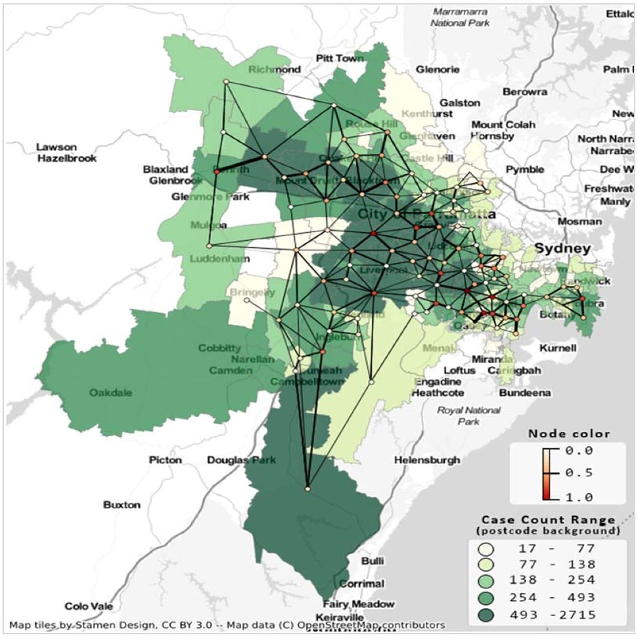
The study measured the ‘degree centrality’ (the number of ‘links’ to a node) of each postal area, finding highly affected top-5 postal areas had 61.2 links on average.
The most severely affected postcodes were 2196 (Punchbowl and Roselands), 2148 (Blacktown, Arndell Park and Prospect), and 2142 (Granville, Holroyd and Rosehill) – suburbs intersected and flanked by some of the city’s busiest roads.
Punchbowl and Roselands in South-West Sydney are crossed by busy roads, including the M5 South-West Motorway, Canterbury Road, Fairford Road, Punchbowl Road and King Georges Road. Granville lies at the very heart of Sydney and south of the intersection between the city’s busiest roads – the Western Motorway, Great Western Highway and Parramatta Road.
Conversely, postcodes with low COVID severity included 2120 (Pennant Hills, Thornleigh and Westleigh), 2125 (West Pennant Hills) and 2234 (Alfords Point, Bangor, Barden Ridge, Illawong, Lucas Heights, Menai and Menai Central).
How the modelling worked
The model analysed ABS data from 19 local government areas (LGAs) of Greater Sydney, New South Wales, Australia during June – September 2021, creating a detailed network of suburbs represented by nodes and edges, demonstrating how suburbs are connected to one another.
“While many studies explored the relation between mobility and COVID-19 propagation, they primarily focused on larger geographic areas, such as whole cities, states, and countries,” said Dr Uddin.
“Given that pandemic policy is determined at a state or local health district level, we wanted to provide a more granular approach – how the movements of people progress across suburbs through local roads and their chances of introducing the virus to adjacent suburbs.”